Technology-shift
Boundary wire vs. satellite: robotic mower navigation trade-offs
The robotic mower category is splitting between physical perimeter-wire installation and satellite-based virtual boundaries, two approaches that differ on setup complexity, positional accuracy under canopy, and maximum achievable autonomy level.
We may earn commission from qualifying purchases. This does not influence the comparison.
The technological divide
Two architectures, two failure modes
The category has split into two architectural approaches. Each works well in some conditions and breaks down in others.
Boundary wire with GPS assist
A wire buried around the lawn marks the exact boundary the robot must stay inside.
A physical wire loop buried or surface-laid around the mowing zone generates a low-frequency signal the mower detects. GPS assist improves internal positioning but the wire remains the hard boundary. Installation is a one-time physical task; wire continuity must be maintained each season.
- Reliable in heavy tree canopy
- No satellite signal dependency
- No zone reconfiguration without re-wiring
- Edge accuracy limited to wire placement
RTK or EPOS satellite positioning
The robot listens to several satellite frequencies at once, so it holds an accurate position even when trees or buildings block some signals.
A fixed reference station or manufacturer satellite network provides centimeter-level positioning. Boundaries are defined digitally in a companion app; no wire is buried. Zone reconfiguration is software-only. Accuracy degrades under dense canopy where satellite signals attenuate.
- Zone redefinition without physical work
- Centimeter-level positioning in open sky
- Signal degrades under dense canopy
- Annual calibration or service required
Where each robot sits
Does the architecture pay off?
Horizontal: where each robot sits between the two architectures. Vertical: its documented result on the headline test.
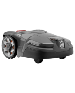
 415XWire-guided
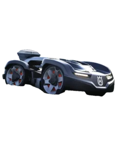
 435X AWD NERAReduced accuracy
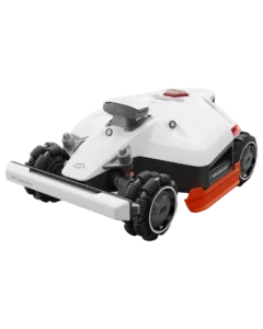
 Mammotion LUBA 2 AWDReduced accuracy
Vertical axis — documented result on: Operates under dense tree canopy
What each architecture can and can’t do
Capability tests
Each capability is documented from owner reports, manufacturer specifications, or third-party reviews. No in-person testing.
415X435X AWD NERAMammotion LUBA 2 AWDWhat the architecture difference means
Different homes, different sensor stacks
Where each architecture fits, by condition.
Yards with mature tree canopy
Properties where overhead canopy covers more than 30% of the mowing zone attenuate satellite signals. Boundary-wire navigation maintains consistent coverage because the guide signal is ground-level and canopy-independent. Satellite-based mowers document reduced positional confidence in these conditions, per manufacturer installation guides and owner reports.
Large properties with irregular or changing boundaries
Yards exceeding 0.5 acres with seasonal obstacles, separate lawn sections, or evolving landscape layouts require boundary changes. Satellite-based systems allow digital zone edits; wire-based systems require physical re-wiring for each change. Owner reports on Mammotion forums document zone reconfiguration in under 20 minutes via app; wire relocation for the 415X requires similar physical effort each time.
Steep slopes beyond wire-mower limits
The Husqvarna 415X is rated to 40% slopes per manufacturer documentation. Both satellite-based mowers carry markedly higher gradient ratings: 70% for the 435X AWD NERA and 80% for the LUBA 2 AWD, both using all-wheel drive with articulated or four-motor traction. Properties with grades above 40% sit outside the wire-based mower documented operating domain.
Common questions